


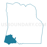
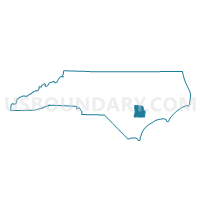
Voting District ROCK, Duplin County, North Carolina
About
Outline

Summary
| Unique Area Identifier | 639913 |
| Name | Voting District ROCK |
| County | Duplin County |
| State | North Carolina |
| Area (square miles) | 49.88 |
| Land Area (square miles) | 49.66 |
| Water Area (square miles) | 0.21 |
| % of Land Area | 99.57 |
| % of Water Area | 0.43 |
| Latitude of the Internal Point | 34.75777540 |
| Longtitude of the Internal Point | -78.13616010 |
Maps

Graphs
Select a template below for downloading or customizing gragh for Voting District ROCK, Duplin County, North Carolina


Neighbors
Neighoring Voting District (by Name) Neighboring Voting District on the Map
- Voting District HARR, Sampson County, NC
- Voting District MAGN, Duplin County, NC
- Voting District ROSE, Duplin County, NC
- Voting District UU17, Pender County, NC
- Voting District WALL, Duplin County, NC
Top 10 Neighboring County Subdivision (by Population) Neighboring County Subdivision on the Map
- Island Creek township, Duplin County, NC (10,390)
- Union township, Pender County, NC (4,232)
- Rose Hill township, Duplin County, NC (3,411)
- Magnolia township, Duplin County, NC (3,140)
- Franklin township, Sampson County, NC (2,228)
- Rockfish township, Duplin County, NC (1,892)
- Taylors Bridge township, Sampson County, NC (1,388)
Top 10 Neighboring Place (by Population) Neighboring Place on the Map
Top 10 Neighboring Unified School District (by Population) Neighboring Unified School District on the Map
- Duplin County Schools, NC (58,505)
- Pender County Schools, NC (52,217)
- Sampson County Schools, NC (47,622)
Top 10 Neighboring State Legislative District Lower Chamber (by Population) Neighboring State Legislative District Lower Chamber on the Map
- State House District 16, NC (93,684)
- State House District 4, NC (82,523)
- State House District 21, NC (69,625)
Top 10 Neighboring State Legislative District Upper Chamber (by Population) Neighboring State Legislative District Upper Chamber on the Map
Top 10 Neighboring 111th Congressional District (by Population) Neighboring 111th Congressional District on the Map
Top 10 Neighboring Census Tract (by Population) Neighboring Census Tract on the Map
- Census Tract 907.02, Duplin County, NC (6,346)
- Census Tract 9710, Sampson County, NC (5,429)
- Census Tract 908.02, Duplin County, NC (5,191)
- Census Tract 9203, Pender County, NC (4,232)
- Census Tract 908.01, Duplin County, NC (3,220)
Top 10 Neighboring 5-Digit ZIP Code Tabulation Area (by Population) Neighboring 5-Digit ZIP Code Tabulation Area on the Map
- 28466, NC (10,103)
- 28458, NC (6,444)
- 28478, NC (4,588)
- 28453, NC (3,829)
- 28464, NC (2,457)
- 28444, NC (2,085)